Butterfield Canyon Bike Climb - PJAMM Cycling

14.1
PDI
6.6 mi
DISTANCE
2,213 ft
GAINED
6.4 %
AVG. GRADE

FULL CLIMB STATS

Page Contributor(s): Bruce Hamilton, La Quinta, CA; Steven Larsen, West Jordan, UT

INTRO

This climb starts southwest of Salt Lake City and is right next to the largest open pit mine in the world. The views initially are dominated by the tiered walls of the mine but soon give way to trees and a canyon.  

If you check the Routes in Area (just below the featured image, above) you'll see how stark this climb is compared to all the other climbs around Salt Lake City. Butterfield Canyon is the only climb south of Salt Lake City in the Oquirrh Mountains instead of the many into the Wasatch Mountains west of SLC.

PLAN YOUR ROUTE

We've partnered with Sherpa-Map.com to bring you the best route planning tool. With a PRO Membership you can use this climb as a reference when creating your route.
6.4% average grade. Ride 6.6 miles gaining 2,230' at 6.4% average grade.  38% of the climb is at 0-5% grade, 53% is at 5-10%, and 9%i is at 10-15%. 

See more details and tools regarding this climb's grade via the “Profile Tool” button.
Roadway: A remote narrow two lane road (narrowing to a wide one lane higher up) in fair condition.
 
Traffic: Minimal.

Parking: On the side of the road at climb start - Map; Street View
Provisions:  There is nowhere to get water or food on the route.  There are plenty of spots for food and beverages in Herriman and Riverton within a few miles of the start of the climb. 
Before heading out on any cycling adventure check out our Things to Bring on a Cycling Trip and use our interactive check list to ensure you don't forget anything.
From PJAMM Ambassador Steven Larsen, West Jordan, UT:  A great time to do this ride. Lots of rocks still on the road but only the occasional maintenance vehicle and fellow cyclists to look out for traffic-wise. Also, if you are on a gravel bike (and the snow has melted) you can drop down the back side into middle canyon (steep) gravel for about a mile and a half then pavement through a peaceful and very beautiful canyon complete with campgrounds down to Tooele valley. The return trip up middle canyon is almost as challenging as Butterfield.

ROUTE MAP

MEMBER RATING

Difficulty: Challenging
3
Road
3
Traffic
4
Scenery

CURRENT WEATHER

PJAMM TRIPS ADVENTURE STARTER BUNDLES

Check out PJAMM Adventure's prepackaged (self-guided) cycling trips. They will help you plan, document and conquer your next adventure.
ALL TRIPS
Browse all of our prepackaged trips and find your next adventure!
The American Southwest
United States (AZ,NM,UT)
18 ROUTES
27 POIs
ROUTE STATS (TOTAL)
215.4
mi
DISTANCE
34,866
ft
ELEV. GAIN
Utah: Moab, Arches & Canyonlands
United States (UT)
19 ROUTES
21 POIs
ROUTE STATS (TOTAL)
325.3
mi
DISTANCE
32,871
ft
ELEV. GAIN
Utah: Zion National Park
United States (UT)
20 ROUTES
32 POIs
ROUTE STATS (TOTAL)
256.5
mi
DISTANCE
39,649
ft
ELEV. GAIN

NEARBY CLIMBS (0) RADIAL PROXIMITY

FROM
No Climbs Found

MEMBER REVIEWS & COMMENTS

Let us know what you thought of this climb. Signup for our FREE membership to write a review or post a comment.
Already have an account?

Jul 27, 2022
difficulty: Challenging
scenery: 4
traffic: 3
road: 3
Jul 27, 2022
scenery: 4
traffic: 3
road: 3
Pretty tough climb, although short and manageable. The couple mile stretch about 4 miles in is where the real challenge is, as the sections before that are pretty easy. As soon as you get above the first 14% grade, the road starts to have a lot of loose rock and gravel, which isn't that hard to navigate going up because you're going pretty slow, but the way down is a bit perilous. Road is quite narrow, so the traffic that does venture in both directions present another challenge. Just hope the drivers are gracious and safe because there's not much room for error. The leading into the canyon don't get much traffic since you're on the edge of the valley, so riding to the climb is a great way to tack on miles.
ROUTE MAP
PROFILE TOOL
Route Data
S.G. (%)
hide
Segment Data
hide
CLIMB SUMMARY

Cycling Butterfield Canyon

Ride 6.6 miles gaining 2,30’ to 7,660’ at 6.4% average grade.

View east to Salt Lake City from the finish.

Summary by PJAMM friend and contributor Bruce Hamilton.

This climb starts southwest of Salt Lake City and is right next to the largest open pit mine in the world.  The views initially are dominated by the tiered walls of the mine but soon give way to trees and a canyon.  

Start

Kennecott Copper Mine

Photo:  TourofUtah.com

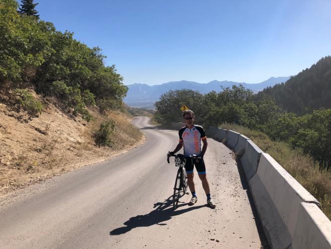
This is not a long climb and the first few miles are easy. The second half of this climb is steep with several sections of extended climbing at 15-16%. The early part of this climb has trees on both sides of the road but the upper half provides wide open views of the canyon and the Salt Lake Valley.

The road becomes quite narrow and there are many places with gravel and dirt strewn across the road. This road is an out and back to nowhere so there are not many cars out there but the road is so narrow that passing a car is tight. Take low gears for this one.

The paved road tops out at 7700 feet but if you ride on a mountain bike or gravel bike with big tires, you could ride the dirt road up to the top to 9000 feet and the Bingham Mine Overlook.

Top of the climb

Thanks Bruce!!

Continue on to the overlook - gravel or mountain bike recommended

Copper Pit Overlook.

Photo:  Alltrails.com